On August 24 Chinquapin soared into the dangerous northeast quadrant of then category 3 Hurricane Irene. The Lockheed Martin C-130 – Hercules, a behemoth of an airplane originally designed for the military to transport troops and equipment like utility helicopters and armored vehicles is the preferred means for crashing through the wall of a hurricane.
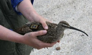
Chinquapin, on the other hand, is about 18 inches long and weighs about a pound. Chinquapin is a whimbrel – a sandy-brown shorebird with dark scallops on its wings and back, fine brown streaking on its breast and long decurved bill. Chinquapin is part of a collaborative long-term study sponsored by The Center for Conservation Biology (CCB), Georgia Department of Natural Resources, The Nature Conservancy, The U.S. Fish and Wildlife Service, the Virginia Coastal Zone Management Program and Manomet Center for Conservation Sciences to study the migration of whimbrels.
Whimbrels are known long-distance migrants, often covering nearly 5,000 miles between their nesting grounds in Alaska and the Northwest Territories of Canada and wintering grounds in Central and South America, however, little was known about the details of this migration. Researchers alarmed by steep declines in whimbrel populations and buoyed by new technology that allows these long distance migrants to be outfitted with tiny (1/3 – ounce) geolocators began capturing whimbrels and outfitting them with the tiny tracking devices to monitor their migration paths.
According to Bryan Watts, director of the CCB, the monitoring is part of an integrated investigation into whimbrel migration. Researchers are learning a great deal about this traveler’s migration habits. Watts said the study is showing the tremendous importance of relatively small areas the birds use for staging and refueling during migration, nesting and overwintering. According to Watts, “Connecting the dots throughout an entire life cycle is something that’s new and just coming over the horizon in the study of migratory birds—the connectivity of places that are separated by such great distances.”
Chinquapin, named after the creek on Little Egg Island Bar, along the coast of Georgia where he was captured in May 2010, already has one amazing migration documented. Chinquapin left Georgia on May 27, 2010 and headed north, possibly breeding in Canada’s Northwest Territories. After the breeding season, Chinquapin meandered over to Coates Island in the northern Hudson Bay where he hung around for 24 days. Then in the early morning hours of August 5, 2010, he was airborne. He flew down the length of James Bay, over Quebec, over Maine and into the open Atlantic. Around August 8, Chinquapin encountered the edge of Tropical Storm Colin and took a 300-mile detour around Bermuda. Chinquapin set down on Playa de Isabela in Puerto Rico on August 10, after five days of non-stop flight covering roughly 3,500 miles.
This year, Chinquapin left Southampton Island in the upper Hudson Bay on August 20 and encountered Irene on Wednesday August 24, after four days of non-stop flight. According to flight data, it looks like Chinquapin made it through most of Irene, before taking a hard right and backtracking just a bit to make landfall on Eleuthera Island in the Bahamas.
Researchers were amazed at the bird’s ability to find a tiny island in the middle of the ocean, in the middle of a hurricane. “They seem to have this amazing ability to know exactly where they are at any time. We’ve had birds go 1,000 to 1,500 miles offshore of Bermuda and still be able to navigate effectively,” Watts said. Signals from Chinquapin’s geolocator on Sunday, August 28, suggest Chinquapin is well and foraging on the island. Researches expect he will rest and recharge for a number of days on the island before making the last leg of his flight to Brazil.

